First-Ever Satellite Image Captures Tsunami Wave From Space (Video)
- Last update: 1 hours ago
- 2 min read
- 124 Views
- WORLD
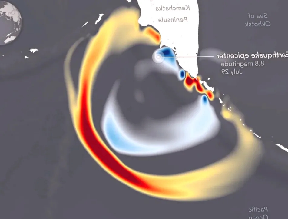
In late July, a powerful earthquake registering 8.8 on the Richter scale shook the Kamchatka Peninsula near Russia. Shortly after, tsunami alerts were issued across nearly all Pacific coastlines, putting communities on high alert. Fortunately, the resulting damage from both the quake and the tsunami was minimal.
Despite the limited destruction, the event offered scientists a unique opportunity to study tsunami behavior, track their movements, and enhance predictive models for future events. Remarkably, for the first time ever, a satellite was able to observe a tsunami directly from space, providing a completely new perspective on these destructive natural phenomena.
The Surface Water Ocean Topography (SWOT) satellite documented the tsunami generated by the Kamchatka earthquake on July 30. By collecting precise information on the waves height, shape, and trajectory, SWOT is helping researchers refine forecasting techniques and bolster coastal safety measures.
A study featuring SWOT data appeared in The Seismic Record, presenting detailed models of the wave created by the massive underwater seismic shift off Russias coast. Angel Ruiz-Angulo from the University of Iceland described the significance of the data, stating, SWOT provides a new lens. Previously, monitoring relied on DART buoys, which only offered isolated readings. Other satellites could capture narrow lines across a tsunami, at best. SWOT can now measure swaths up to 120 kilometers wide, delivering high-resolution observations of the sea surface.
NASA highlighted the importance of this advancement, noting that the new observational method could ultimately save lives. SWOT supplied a multidimensional view of the tsunamis leading edge from the Kamchatka quake. By capturing data on its height, shape, and direction, the satellite enables scientists to enhance forecast models and better protect coastal populations, NASA stated.
This milestone in satellite monitoring marks a major step forward in understanding and preparing for future tsunami events.
Author: Benjamin Carter
Share

The Kremlin receives a gift in the form of the EU's top diplomat
8 minutes ago 3 min read WORLD

Myanmar residents cast early votes in Bangkok
10 minutes ago 2 min read WORLD
Sudanese paramilitary drone strike results in deaths of 50 people, including 33 children in Kordofan, according to doctor group
21 minutes ago 2 min read WORLD

Significant advancements in borough's revitalization efforts
25 minutes ago 2 min read WORLD

'Collective punishment': West Bank suspect's family home demolished
34 minutes ago 3 min read WORLD

Hong Kong leader emphasizes the importance of discovering the truth following fatal apartment fire, urges building reform.
36 minutes ago 2 min read WORLD

Chair with reputed 'healing powers' granted protected status
36 minutes ago 3 min read WORLD

Council temporarily halts dry recycling service
36 minutes ago 1 min read WORLD

Democrats release never-before-seen photos of Jeffrey Epstein's island
38 minutes ago 2 min read WORLD

Cincinnati Children's to Introduce Helicopter Service for Ill Children
38 minutes ago 2 min read WORLD