Old Google Earth image misinterpreted in Sudan crisis posts
- Last update: 2 days ago
- 3 min read
- 348 Views
- WORLD
Reports of alleged executions by Sudan's paramilitary Rapid Support Forces (RSF) after taking control of El-Fasher have caused global concern. However, a widely circulated Google Earth image claiming to show piles of bodies in the city is misleading.
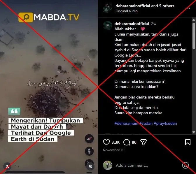
The image in question is outdated and actually depicts a town approximately 400 kilometres (250 miles) from El-Fasher. An expert confirmed to AFP that the shapes in the image are livestock, not human remains.
A Malay-language Instagram post shared on November 10, 2025, claimed, "Now the piles of bodies and blood of the martyrs in Sudan can be seen from Google Earth." The accompanying video showed a zoomed-in satellite view of dark ground with shapes resembling bodies.
The visuals were also shared on Facebook and Threads, spreading to countries including South Africa, the Philippines, Iraq, Vietnam, Indonesia, and Bangladesh. Many viewers reacted with crying emojis and prayers, indicating they believed the images.
The RSF has faced accusations of mass killings and other atrocities since capturing El-Fasher, the army's last stronghold in western Darfur, on October 26, 2025. The RSF has been in conflict with the Sudanese army since April 2023.
A Yale University Humanitarian Research Lab report stated that satellite imagery suggested a large portion of El-Fasher's population may be "dead, captured, or in hiding," identifying at least 31 clusters consistent with human bodies in various areas. However, the circulating image is unrelated to the alleged events in El-Fasher.
Reverse image searches traced the image to an Instagram post from November 14, 2025. Google Earth data shows the location as "Kumia, Sudan," 400 kilometres from El-Fasher, with coordinates included in the post. Historical imagery confirms the photo dates back to March 16, 2024, with similar scenes visible in February 2024 and March 2022.
Open-source investigator Benjamin Strick told AFP that the area in the image features many locations that look similar, suggesting they are livestock gathering sites. Shadow analysis from structures like a water tower indicated that the shapes could not be human bodies lying flat. Strick explained, "A body has to be pretty big in order to leave a shadow if it's lying flat on the ground. It's probably a camel line, because camels like to stand in lines, especially when they're in convoys."
The dark patch on the ground, interpreted by some as blood, is more likely a mix of manure and water. This dark area is consistent across satellite images dating back to 2022. AFP Fact Check has debunked multiple misleading claims related to the Sudan crisis.
Author: Sophia Brooks
Share
Scientists amazed to find species that disappeared for nearly a century: 'First verified sighting'
10 seconds ago 2 min read WORLD
Outrage over footprints found on newly constructed path
2 minutes ago 2 min read WORLD
Cash machine ram-raid destroys building society.
3 minutes ago 1 min read WORLD

JD Vance declares that his relationship with Usha is 'stronger than ever'
4 minutes ago 2 min read WORLD

Stormont leaders tell PM that budget was a 'missed opportunity' for Northern Ireland
6 minutes ago 3 min read WORLD

Widow joins Christmas river patrols
6 minutes ago 2 min read WORLD

German parliament committee rejects BSW challenge to election outcome
7 minutes ago 2 min read WORLD

Charity's respite breaks to be discontinued due to funding cut
9 minutes ago 2 min read WORLD
Incredible discovery of figurines in Egyptian tomb solves mystery
9 minutes ago 3 min read WORLD

Mother's eight-year fight for justice to see rapist behind bars
10 minutes ago 2 min read WORLD