Measuring the mountains of Colorado step by step
- Last update: 1 days ago
- 4 min read
- 512 Views
- TRAVEL
In the early hours of a crisp October night in 2025, three friends and I began our ascent from Cottonwood Creek trailhead into the Sangre de Cristo mountains of Colorado. The temperature hovered just below freezing at 1:30 a.m., and the moon cast a silver glow over the snow-dusted peaks. Our backpacks were heavier than usual, loaded with precision surveying instruments to measure two summits exceeding 14,000 feet (4,267 meters): Crestone Peak and East Crestone.
These neighboring peaks are close in height, with a short connecting saddle. By Colorado standards, only the taller of the two qualifies as a true 14er, while the shorter is considered a sub-peak. Historically, Crestone Peak has been regarded as the higher summit, attracting hundreds of climbers annually, while East Crestone receives far fewer visits.
Colorado boasts 58 officially recognized 14,000-foot peaks. Climbing them, or bagging 14ers, is popular among locals and tourists, with some attempting to summit all 58. My aim was to determine which of these two peaks is actually taller, as I suspected that longstanding measurements might not be entirely accurate.
I teach mountain surveying and pursue high-altitude climbs worldwide. My goal is to reach the highest points of every country, having already summited 147 of 196 peaks, including challenging ones like K2 without supplemental oxygen. In my experience, not all countries have accurate surveys of their highest points, which are geographically and culturally significant. I have personally verified new high points in seven countries, including Colombia, Saudi Arabia, Uzbekistan, Togo, Gambia, Guinea-Bissau, and Botswana.
Within the U.S., Ive surveyed over 60 mountains. In 2025, I identified Michigans Mount Curwood (1,979.3 feet / 603.3 meters) as a new state high point, and Nova Scotias Western Barren (1,743.2 feet / 531.3 meters) as a provincial high point. I have mapped the 100 tallest peaks in Washington state and studied the impact of climate change on ice-capped summits. My research revealed that only two ice-capped peaks remain in the contiguous U.S.: Liberty Cap and Colfax in Washington, whereas Mount Rainiers historic ice dome, Columbia Crest, has shrunk, shifting the highest point to an exposed rock.
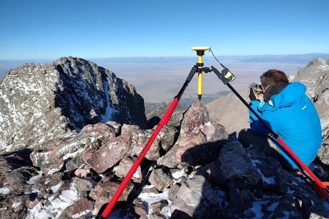
Surveying mountains requires overcoming altitude, weather, long approaches, and technical climbing challenges. Carrying precise equipment to summits demands careful planning and lightweight, adaptable gear. Traditionally, peak heights were estimated from afar using theodolites, which calculate elevation based on angles and distances. However, long-distance measurements can introduce errors. I sometimes haul a 30-pound theodolite for accuracy, but often use lighter Abney levels for relative height measurements. Absolute elevations are then recorded with survey-grade GPS, which requires precise placement on the summit and data collection over time to achieve inch-level accuracy.
In addition to ground measurements, I utilize LiDAR, which uses airborne lasers to map elevations. Despite its accuracy, LiDAR can miss sharp peaks or register vegetation, resulting in slight errors. This prompted me to measure Crestone and East Crestone myself, as LiDAR indicated they were nearly identical in height, with a small spike on Crestone possibly caused by a climber.
On East Crestone, I set up a tripod that had to withstand strong winds, while on Crestone, a GPS tripod was extended with a hiking pole over a cliff edge. I collected data for over two hours from both peaks simultaneously to ensure precision. Analysis revealed that East Crestone is 0.3 feet (0.09 meters) taller than Crestone, confirming it as Colorados newest 14er, while Crestone is reclassified as a sub-peak. Discussions continue regarding whether the traditional 14er list should expand to 59 peaks or replace Crestone with East Crestone to maintain 58.
My work continues, both in Colorado and internationally, to refine summit elevations. This winter, I plan to survey several high points in Africa, including the still-unverified peak in Benin.
Author: Connor Blake
Share

India’s largest airline cancels numerous flights, causing chaos for holiday travelers
40 minutes ago 1 min read TRAVEL

Travel Experts Advise Against Visiting Glacier National Park in 2026
50 minutes ago 3 min read TRAVEL

Over 100 passengers and crew members fall ill in cruise ship norovirus outbreak
2 hours ago 2 min read TRAVEL

French Senate approves new €15 per passenger tax for cruise ships
3 hours ago 2 min read TRAVEL

Edinburgh Airport resumes operations following air traffic disruption that caused flight delays
3 hours ago 2 min read TRAVEL

How Travelers Can Stay Safe from 'Juice Jacking', According to the TSA
3 hours ago 2 min read TRAVEL

Delta imposes temporary halt on flights to Detroit Metro Airport
4 hours ago 1 min read TRAVEL

Plans to Expand US Travel Ban to Over 30 Countries Unveiled by Head of Homeland Security
4 hours ago 2 min read TRAVEL

DFW CEO Not Worried About New Airport Development
4 hours ago 2 min read TRAVEL

Detroit Airport in Chaos following Ground Stop for Delta Flights
4 hours ago 1 min read TRAVEL