Polar vortex shift to bring more bitter cold to US through mid-December
- Last update: 1 hours ago
- 3 min read
- 336 Views
- WORLD
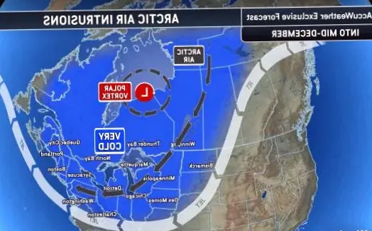
As one wave of Arctic air moves out to sea, a new surge of frigid air, triggered by a disruption in the polar vortex, is expected to spread from central Canada into the Midwest and Eastern United States by early next week. Meteorologists indicate that these Arctic blasts could continue in waves until past mid-December.
The polar vortex is a large, high-altitude low-pressure system that typically hovers above the Arctic Circle. When strong, it traps the coldest air over the pole. However, when it weakens or stretches, icy air can spill southward.
"Since late November, the polar vortex has been weakened and stretched," said AccuWeather Lead Long-Range Meteorologist Paul Pastelok. "As a result, Arctic air has been moving south across the central and eastern U.S. and may continue in successive waves for the next couple of weeks."
Timing of the Next Arctic Surge
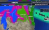
The next wave of Arctic air is forecast to move from the northern Plains on Saturday, reach the Midwest by Sunday, and push into the East by Monday. Temperatures in parts of the Midwest could fall below zero Fahrenheit on Monday morning, which is 15 to 25 degrees lower than the historical average.
"We anticipate two to three additional bouts of severe cold from the Midwest to much of the East between December 10 and 19," Pastelok added. "Late next week, frost or freeze conditions could even reach central Florida."
With limited sunlight and long nights during this season, temperatures can drop quickly and remain low for extended periods. Each cold wave could be colder than the previous, especially in areas with fresh snow cover. Even the Southeast may experience occasional Arctic air intrusions.
Record Lows and RealFeel Temperatures
For example, New York City recorded a season-low of 24 degrees in Central Park on Thursday morning, with forecasts suggesting temperatures could dip into the teens next week. Wind and other factors may cause RealFeel temperatures to be 10 to 20 degrees colder than actual readings.
Snow and Winter Weather Impacts
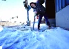
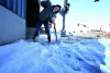
Many of these Arctic air waves are expected to bring snow, flurries, snow showers, and heavier squalls, creating slippery roads and potential travel disruptions. As temperatures fall behind snow events, untreated surfaces may freeze, forming ice.
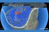
"The rapid movement of these cold waves generally prevents massive snowstorms," Pastelok said. "However, around December 12, an Alberta clipper may slow enough over the Atlantic to gather extra moisture, potentially bringing significant snow to mid-Atlantic and New England cities."
There is also potential for ice or wintry mix events from the Great Lakes to the Ohio Valley and parts of the Appalachians around December 13-14.
Outlook for Late December
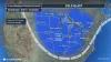
Pastelok noted that the cold may ease by the week of Christmas, depending on the next weakening of the polar vortex around December 14. La Nia conditions are expected for the last 10 days of December, bringing wet and snowy weather to the Rockies and Northwest, and possibly even storms reaching Southern California.
Author: Jackson Miller
Share
View images of arctic cold wave affecting the Midwest and Northeast.
43 minutes ago 2 min read BUSINESS
Three polar vortices cause temperatures to drop in central and eastern U.S. as the first Arctic cold front arrives
4 hours ago 3 min read WORLD
Three polar vortices cause temperatures to drop in central and eastern U.S. as initial Arctic cold front approaches
4 hours ago 3 min read WORLD
Pacific Northwest preparing for heavy rain and snowfall as December storms approach
5 hours ago 3 min read WEATHER
Three polar vortexes will bring Arctic cold to central and eastern U.S. until mid-December.
6 hours ago 3 min read WORLD

Arctic cold from polar vortex to hit US with triple impact until mid-December
1 days ago 3 min read WORLD
Get ready for a third round of the Polar vortex
1 days ago 1 min read ENTERTAINMENT
Expert warns of upcoming extreme cold in US region: 'Temperatures dropping sooner than ever'
1 days ago 3 min read WORLD

Weather Terminology: Unexpected Stratospheric Heating
2 days ago 1 min read ENTERTAINMENT
Possible weekend snow in eastern US following first of three polar vortex episodes.
2 days ago 3 min read WORLD